2025.03.21
1. Pressure
A.M. Barometer

[Surface Weather Chart]
A low pressure system southward from the northeastern part of the Korean Peninsula and a migratory high pressure system approaching from inland China and the South China Sea will meet to form a trough of clouds over the western part of the Korean Peninsula.
Therefore, the clouds will quickly clear due to the influence of the mobile high pressure.

[700hPa Weather Chart]
The Korean Peninsula will develop a pressure trough influenced by low pressure located in the northern part of the Korean Peninsula and high pressure located in the South Sea.
Cloud bands are expected to form.
However, it is not expected to be accompanied by precipitation due to the high pressure moving eastward toward the Korean Peninsula on the surface.
P.M. Barometer

[Surface Weather Chart]
With a trough of low pressure over the northern part of the Korean Peninsula, southwesterly winds are likely to prevail over the peninsula following a counterclockwise circulation.
In addition, due to the influence of high pressure accompanied by cold and relatively moist air located off the southern part of the Korean Peninsula and low pressure located in the north, a pressure trough is expected to develop over the Korean Peninsula and cloud bands are expected to form.
Clouds will form in the Seoul area, but the clouds will quickly clear due to the influence of a mobile high pressure system.

[700hPa Weather Chart]
The Korean Peninsula is located in a barometric trough.
Due to the absence of moisture over the Korean Peninsula and the East Sea and the influence of high pressure approaching the southern part of the Korean Peninsula in the surface weather chart,
it will not bring precipitation to the Seoul area.
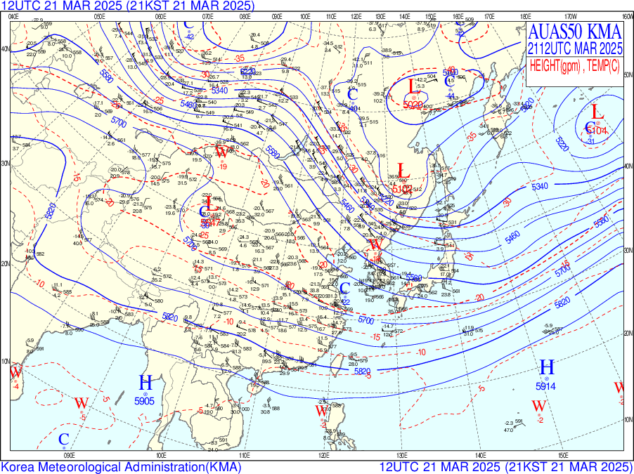
[500hPa Weather Chart]
The area around the Korean Peninsula is warming rapidly. This is due to heated air and high pressure inland.
Under the influence of high pressure, the surface and the lower layers of the atmosphere are gradually heated by the sun as China continues to enjoy clear weather.
This heated air is then carried by westerly winds to the Korean Peninsula, where we also experience clear weather and warmer temperatures. There has also been little precipitation in China, so dry air will be blowing in.
2. Cloud & Precipitation
[AM satellite image]


[PM satellite image]

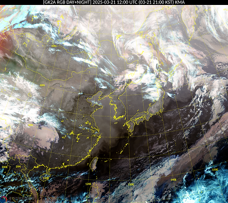
Water vapor image shows water vapor entering the vicinity of Seoul,
In the morning RGB day/night composite image, you can see that there are low level clouds forming over Seoul.
In the afternoon, there are no clouds in the Seoul area and the sky is clear.
[Daily precipitation]

No precipitation occurred across the Korean Peninsula.
3. Temperature
Maximum Temperature

According to the skew-t log-p diagram,
the predicted minimum temperature on the morning of the 21st is 5℃.
However, as the southerly winds are blowing in the Seoul area, the radiation effect will decrease and the minimum temperature will increase.
Therefore, the minimum temperature on the morning of March 21st is predicted to be
around 6-8℃.
Maximum Temperature


According to the skew-t log-p diagram, the predicted afternoon maximum temperature
on the 21st is 20℃.
However, the temperature is expected to decrease as a cold front enters the Seoul area.
Therefore, the afternoon maximum temperature on March 21st is predicted to be around 17-18℃.