2025.03.18
1. Pressure
A.M. Barometer

[Surface Weather Chart]
The Korean Peninsula is under the influence of low pressure and is located in a trough.
Under the influence of the trough, a convergence band is formed and an updraft occurs,
cold air from the northwest and moisture from the west will meet and develop snow.


[700hPa Weather Chart & Humidity and Water Vapor Image]
The Korean Peninsula is located in a trough.
The atmosphere is unstable due to low pressure and moisture in the interior of the Korean Peninsula and over the East Sea, and the influx of cold air masses is causing snow clouds over the East Sea.
It can also be seen that the low pressure developed in the upper layers caused the low pressure to develop in the lower layers, which caused the low pressure to develop on the surface.
As a result, heavy snow is expected to fall in the Seoul area.
The humidity chart shows a moist atmosphere over the east coast and central part of the Korea.
The water vapor image also shows that water vapor is distributed over the entire Korean Peninsula.
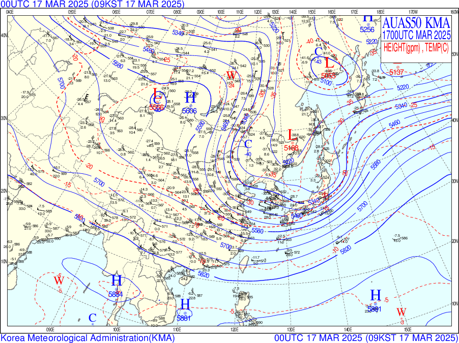
[500hPa Weather Chart]
Air plunging down from Siberia has developed a polar low pressure(mesoscale low pressure) with strong rotation due to instability caused by temperature differences. This low pressure is expected to move inland from the central western sea and exit into the southern East Sea.
Dense contour lines indicate very heavy snowfall,
Jeollanam Province, where the center is located, will receive the most precipitation.
P.M. Barometer

[Surface Weather Chart]
High and low pressure systems of different nature met on the ground and developed a pressure trough, Snow will fall in Seoul under the influence of a cloud belt developed by a low pressure system located over the East Sea of the Korean Peninsula.
In addition, cold air will be brought in by the northwest winds, which will bring a lot of snow to the East Sea.
Therefore, Seoul will receive a lot of snow due to the high pressure northeast winds and low pressure east winds and topographic effects.


[700hPa Weather Chart, Moisture, Water Vapor Image]
The low pressure system located on the Korean Peninsula has moved to the East Sea, but it is still under the influence of low pressure. Compared to the surface weather chart, the surface is also an unstable atmosphere and snow will fall due to the influence of the low pressure.
The humidity chart shows a moist atmosphere over the east coast.
The water vapor image also shows that water vapor is distributed across the Korean Peninsula, especially on the east coast.
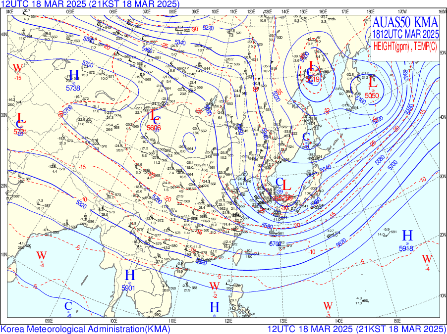
[500hPa Weather Chart]
Low pressure has shifted from the center of the West Sea to the center of the East Sea.
An extreme low pressure system is developing with a central pressure drop of 150 gpm.
As easterly winds blow off the east coast, a lot of snow will continue to fall, especially in the east.
2. Cloud & Precipitation
[AM satellite imagery]


[PM satellite imagery]


In the water vapor image, water vapor entering the Korean Peninsula is re-routed in the afternoon and passes away from the peninsula.
In the RGB day/night composite image, thick clouds moved westward through Seoul during the morning. By the afternoon, it is located near the East Sea.
As a result, a lot of snow is expected to fall in Seoul during the morning of the 18th, the snow is expected to stop in the afternoon.
[Daily precipitation]
.png)
[New snowfall(daily)]

Precipitation has fallen in most of the Korea, with Seoul recording about 9.9mm of precipitation in a single day. This is the most precipitation since December 2024 through March 2025.
Seoul's highest new snowfall of the day was 8.7 cm at 08:00, indicating a strong snowfall.
3. Temperature
Minimum Temperature


According to the skew-t log-p diagram, the predicted minimum temperature on the morning of the 18th is 1℃.
However, according to the 500 hPa weather chart, a cold advection is entering the Seoul area.
Therefore, the minimum temperature on the morning of March 18th is predicted to be around
-1 - 1℃.
Maximum Temperature

The maximum temperature on the afternoon of the 18th, which is also analyzed in the weather chart, is 5°C.
Therefore, the afternoon high temperature on March 18th is predicted to be around 5-6℃.