2025.03.17
1. Pressure
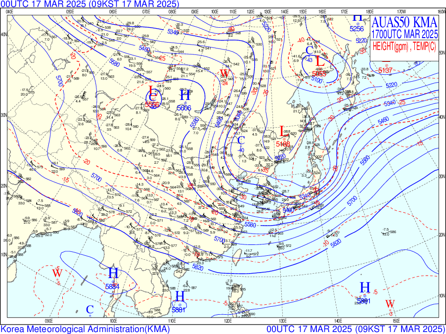
A.M. Barometer

[Surface Weather Chart]
A low pressure system located over the east coast of the Korean Peninsula and a high pressure system located over the southern sea of the Korean Peninsula met and formed a trough over the Korean Peninsula.
Cloud bands are formed under the influence of the ridge, but the trough located over the East Sea is gradually exiting, and precipitation is expected to gradually stop under the influence of high pressure moving southward from northern China.

[700hPa Weather Chart]
The Korean Peninsula still seem to be under the influence of low pressure. It is also expected to be gradually influenced by high pressure as the high pressure inland China moves eastward.
In addition, the isobars and temperature lines are not parallel on the Korean Peninsula,
so there is a cold advection.
[500hPa Weather Chart]
An inland trough on the 16th moves eastward rapidly.
The weather will be increasingly clear under the influence of the high pressure moving south,
but it will quickly exit to the east. The east coast is still under the influence of the trough, but the weather will soon be cleared by the high pressure moving south.
P.M. Barometer

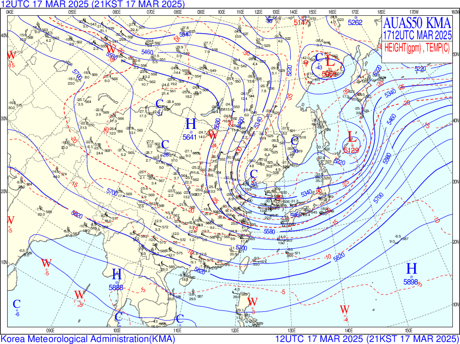
[Surface Weather Chart]
In the afternoon, warm and unstable air is expected to enter the Korean Peninsula due to the influence of a low pressure system located over the western coast of the Korean Peninsula,
bringing precipitation.
In particular, Seoul is expected to receive a large amount of precipitation.


[700hPa Weather Chart & Humidity and Water Vapor Image]
Moist air is expected to enter due to moisture over the Korean Peninsula and East Sea. Clouds and precipitation are expected due to the influence of a trough located over the west coast of the Korean Peninsula. Snow is also expected to fall in Seoul due to a cold advection.
It can also be seen that a migratory high pressure system located inland of China is moving eastward.
(It is likely a migratory high pressure based on spring characteristics [when migratory high pressure is active], location [Siberia-Mongolia channel], and eastward pattern).
The humudity image shows a moist atmosphere over the Korean Peninsula.
The water vapor image also shows the distribution of water vapor over Seoul.
[500hPa Weather Chart]
The Air-Sea Temperature Difference (ASTD) between the cold air from the north and the warmer western water has led to the formation of an occlusive low pressure system and precipitation.
The isobars have also narrowed in spacing, and strong winds are expected. This structure is prone to strong updrafts and concentrated cooling, which is likely to trigger heavy snowfall in the lower atmosphere.
There is also a trough and ridge on the north of China with a narrow barometric gradient, which could compress the jet stream and maximize the dynamics.
2. Cloud & precipitation
[AM satellite image]


[PM satellite image]


The water vapor image shows that water vapor from the north is moving strongly
through the Seoul area.
In the RGB day/night composite image, thick clouds are approaching the Korean Peninsula,
and a direct path through the Seoul area.
Based on the temperature and satellite image for the day, snow is expected to begin to fall overnight in the Seoul area.
[Daily precipitation]
.png)
[New snowfall(daily)]
.png)
Precipitation and snowfall have occurred along the west and east coasts.
In the Seoul area, thick clouds began to move through at night.
The 24-hour new snowfall chart on the 17th recorded about 0.3cm.
Precipitation in the Seoul area was light rain, around 0.4mm.
3. Temperature
Minimum Temperature


According to the skew-t log-p diagram, the minimum temperature on the morning of the 17th is predicted to be -8℃.
However, the 500hPa weather chart shows that a warm advection is entering the Seoul area.
In addition, there are northerly winds blowing in the Seoul area,
which will increase the minimum temperature.
Therefore, the minimum temperature on the morning of March 17th is
predicted to be around -3~-2℃.
Maximum Temperature


According to the skew-t log-p diagram,
the forecasted afternoon maximum temperature on the 17th is 2.5℃.
However, the temperature is expected to rise as convective clouds form in the Seoul area.
Therefore, the afternoon maximum temperature on March 17th is predicted to be around 4.5-6℃.