2025.03.20
1. Pressure
A.M. Barometer

[Surface Weather Chart]
A low pressure system located in the northern part of the Korean Peninsula and a high pressure system located in the southern part of the Korean Peninsula will develop a trough over the western part of the Korean Peninsula, causing cloud bands to form.
The Korean Peninsula will be under the influence of a migratory high pressure system, which will bring in cold and dry air, so Seoul will be mostly sunny.

[700hPa Weather Chart]
The Korean Peninsula will be affected by high pressure located in southern China, which will bring in dry and cold air.
Also, according to the Surface Weather Chart, high pressure of southern China and high pressure inland China are affecting the Korean Peninsula, bringing in cold and dry air.
Therefore, it is expected to be sunny in Seoul due to the inflow of cold and dry air from the upper layers and the surface atmosphere.
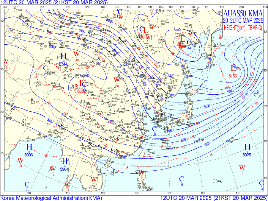
P.M. Barometer

[Surface Weather Chart]
Cold high pressure located in the southwest of the Korean Peninsula and low pressure in the northern part of the Korean Peninsula will meet and develop a trough in the west of the Korean Peninsula. The flow of the trough and the high pressure located in the northwest are expected to meet and form a cloud band.
As a result, clouds will form in the Seoul area, but the weather will become clear again due to the influence of the migratory high pressure.


[700hPa Weather Chart, Humidity image]
Due to the influence of low pressure located in the northern part of the Korean Peninsula, the Korean Peninsula appears to be located in a trough. The atmosphere is unstable and moist air is expected to flow in from the northern part of the Korean Peninsula.
However, the high pressure located in the western part of the Korean Peninsula (inland China) will bring in cold and dry air, this is unlikely to bring precipitation to the peninsula.
Also, the surface weather chart shows that due to the high pressure located in the southern part of the Korean Peninsula and the high pressure located in the interior of China, cold and dry air will bring no precipitation to the Seoul area.
The humidity chart shows a dry atmosphere across the Korean Peninsula.
[500hPa Weather Chart]
Due to the S-N pressure pattern (high pressure south, low pressure north) created between the high pressure and the trough located in the north of the Korean Peninsula, the pressure gradient is strengthened and westerly winds are strongly introduced.
Strong winds are expected in Gangwon and Yeongdong provinces.
2. Cloud & precipitation
[AM satellite image]


[PM satellite image]


The water vapor image shows a weak water vapor inflow near Seoul.
In the RGB day/night composite image, you can see the formation of lower clouds over Seoul.
[Daily precipitation]

No precipitation occurred across the Korean Peninsula.
3. Temperature
Minimum Temperature

The minimum temperature on the morning of March 20th is 2℃, which is also analyzed in the weather chart.
Therefore, the minimum temperature on the morning of March 20th is predicted to be
around 2-3℃.
Maximum Temperature

According to the skew-t log-p diagram, the predicted afternoon maximum temperature on the 20th is 13℃.
Therefore, the afternoon maximum temperature on March 20th is predicted to be around 13-15℃.